Sunday 19th April 2026

Plenty more dry, sunny and pleasant weather to come, a bit cooler for a couple of days, but somewhat warmer from mid-week onwards.

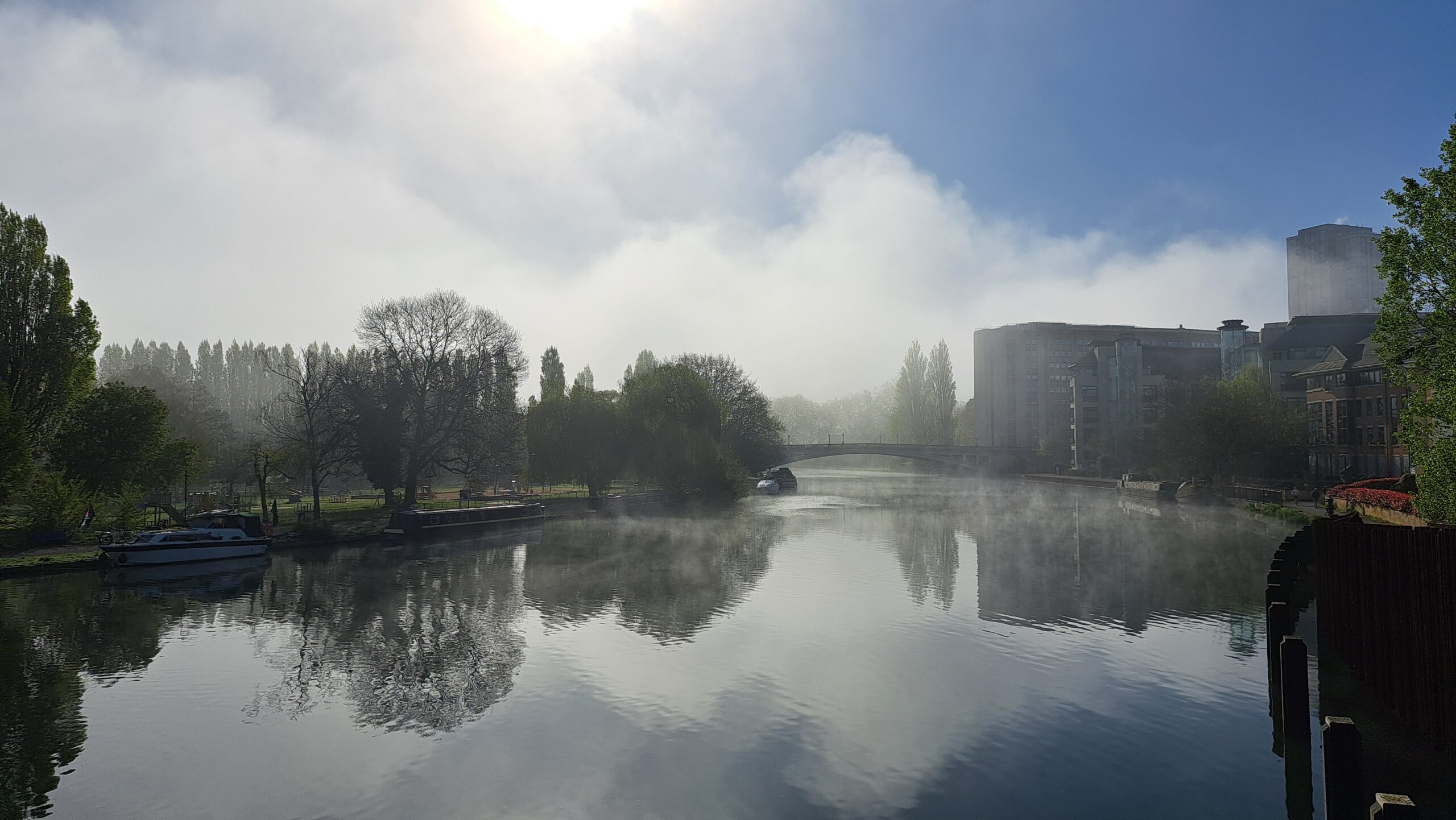
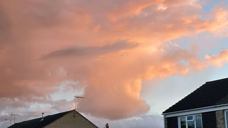
Thanks to Peter for the photograph (and to several others that saw my hint!).

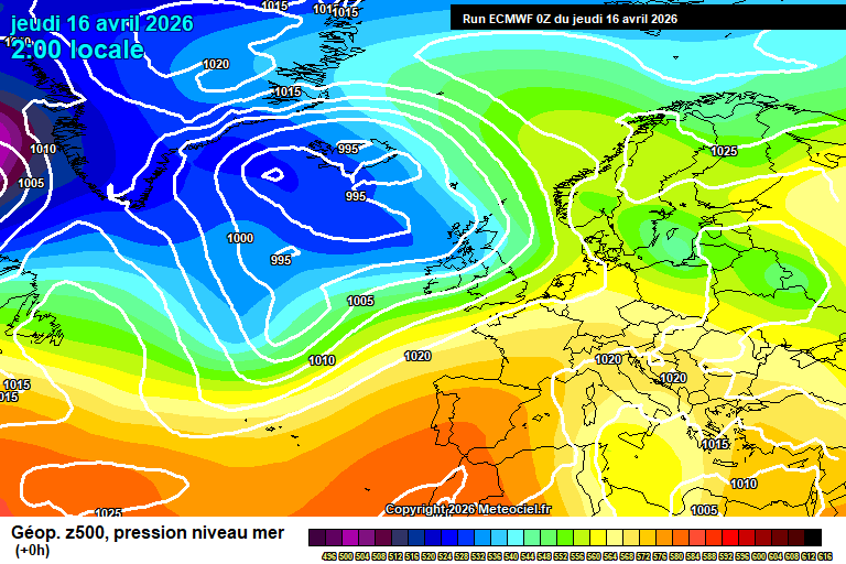
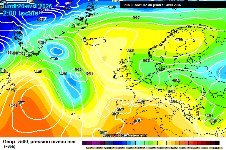
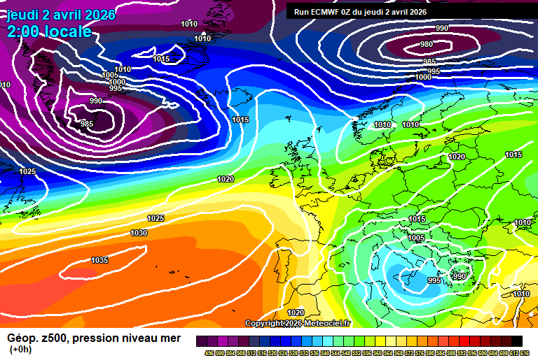
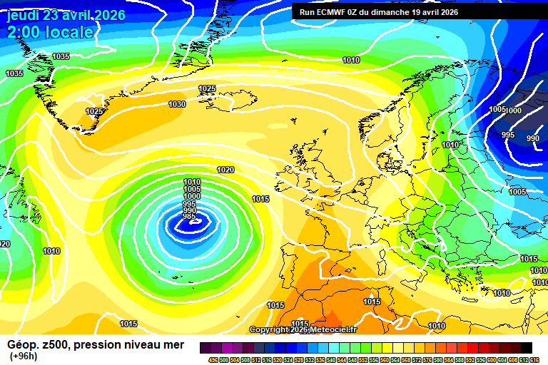
So the general picture sees high pressure building over the UK, though that is going to head north and centre itself over Iceland – bringing the cooler easterly flow to start the week.

Sunday starts sunny. Cloud will bubble up from around midday onwards, though there will still be sunny spells. I cannot totally rule out the chance of a light shower by late afternoon, but it’s unlikely. Around 15’C. Reasonably clear skies overnight, down to around 3’C – a small chance of mist/fog patches by dawn.

Monday starts sunny again, and again quite a bit of cloud bubbling up from around midday onwards. A 30% chance of a shower or two in the afternoon. Feeling a bit cooler in the easterly breeze, around 13’C. Some cloud, some clear spells overnight – down to around 4’C.

Tuesday sees a mixture of cloudy spells and sunny spells – sunshine generally more likely in the afternoon. Quite windy and the wind taking the edge off the temperatures, though still around 14’C or so. Mostly clear skies overnight, down to around 4’C.

Wednesday sees long spells of sunshine, probably some high cloud around at times, more so in the afternoon but very pleasant and temperatures nudging up to around 16’C. The easterly wind more of a breeze and turning south-easterly. Some cloud, some clear spells overnight, roughly down to around 5’C.

High pressure still in control by Thursday with a more south-easterly flow allowing something warmer.

There may be some cloud around at times on Thursday morning but more likely it is mostly sunny all day. Quite warm, reaching around 18’C – still with a breeze but the breeze not as cool. Down to around 5’C overnight – potential for mist/fog or low cloud to develop.

Friday may well start with mist/fog/low cloud but this will lift during the morning to long spells of sunshine. Quite warm, around 18’C or so, maybe a tad more. Clear skies overnight though mist/fog/low cloud may form towards dawn again.

Saturday again may start with mist/fog/low cloud but this will lift to long spells of sunshine again. Temperatures more likely somewhere between 17’C and 20’C – though cooler air will be trying to spread down from the north too, so a small chance that it is cooler instead. Say 80% chance the warm air can hang on into Saturday.

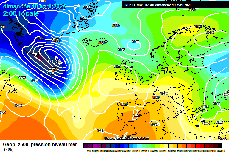
By Sunday more likely the cooler weather has spread down from the north, say 70-80% chance, so temperatures back in the range of 10’C to 13’C – uncertainty on cloud/sunshine amounts but most likely dry.

More dry and sunny weather is likely for the end of April and beginning of June, more likely cool to start but it should warm up at least somewhat.

Not bad, huh.…

Thursday 16th April 2026

Not a very interesting forecast ahead, but I’ll try to make it more so – fairly dry, sometimes sunny, temperatures roughly around normal for mid-April.

Thanks to Kate for the photograph.

The general picture sees low pressure close-ish to our north-west, high pressure to the south – and a further ridge of high pressure far to the west (just east of Canada) which will take over during the weekend in the UK.

Today will be fairly cloudy with some occasional showers – though also some bright/sunny spells at times too. Around 16’C in a moderate breeze. Quite a lot of cloud overnight, the odd showery bit of rain, around 9’C.

Friday will again be fairly cloudy, some occasional bits of light/moderate rain but also some bright spells with hazy sunshine too. Quite warm, around 17’C, quite windy by late afternoon. A more organised band of rain will cross in the evening, though still pretty limited rainfall amounts, skies clearing for the second half of the night – down to around 5’C.

Saturday sees high pressure building from the west. Some cloud, some sunny spells – and a chance of a shower or two though should be on the light side if you catch one. Around 15’C, maybe a tad more. Mostly clear skies overnight and fairly chilly, down to around 4’C.

Sunday looks fairly sunny, especially in the morning with long spells of sunshine. Some cloud gradually bubbling up during the afternoon – perhaps a shower later in the day. Around 15’C. Mostly clear skies overnight and chilly, down to around 3’C.

By Monday we start to pick up an easterly flow – and the source is pretty cold.

Likely more cloud than sunshine overall, a fair chance of some showers developing and feeling cooler in the wind – around 11’C or so. Remaining fairly cloudy overnight, showers still possible and down to around 5’C.

Tuesday fairly similar, probably more cloud than sunshine (though uncertain), a chance of showers and around 12’C – though feeling cooler in the wind.

Details more uncertain from Wednesday – uncertain on cloud/sunshine amounts, temperatures probably recovering a bit to around 14’C, probably dry.

Perhaps for Thursday/Friday the flow will be more south-easterly, so a warmer direction and around 18’C – though this is very tentative right now. Dry and sunny more likely than cloud.

Next weekend is interesting, much warmer air will be trying to spread up from the south at the same time as Arctic air will be trying to spread down from the north. Which will win out? My money is on the Arctic air, alas. But next weekend is a long way away. Of course, something else entirely could happen, but they are the two more likely outcomes.

It does seem like the imprint from the sudden stratospheric warming event back in early March has finally started dripping down into the troposphere (the layer where our atmosphere/weather is), so we’ll have to assume that northerly and easterly flows are more likely than normal going forwards. That said, easterly flows are more common this time of year anyway.

Also we’ve had the final warming of the polar vortex for the season, and that can cause northerly flows – so maybe it’s just that about to (probably) have an effect.

As always with medium/long range forecasting, there’s a lot of mystery. Have a good end to the week/weekend – I should be back on Sunday morning.…

Sunday 12th April 2026

Showery vibes for the first few days giving way to something drier later next week.

Thanks to Karen for the photograph – doesn’t quite match the weather but the only one left in my inbox!

The general overview sees low pressure to the north-west of Scotland, driving a more showery regime for a few days.

Sunny spells to start Sunday but showers will develop during the morning, becoming more frequent in the afternoon and most places catching a few, probably heavy, a small chance of hail/thunder mixed in. Around 14’C and breezy, especially in showers. Showers fading this evening, reasonably clear skies overnight and pretty chilly – down to around 2’C.

A chance of some mist/fog patches around dawn, but they will quickly lift and leave sunny spells. Again cloud bubbling up during the morning with some showers breaking out – but fewer than on Sunday, and less of them will be heavy, you may even miss them all. Around 13’C and breezy. A chilly night overnight, down to around 2’C.

Tuesday again has a small chance of some mist/fog patches around dawn but they’ll clear quickly to sunny skies. Cloud gradually thickening during the afternoon as a weather front approaches. Reaching around 15’C – becoming quite windy in the afternoon again. Cloudy overnight, perhaps some patchy light rain at times – around 11’C.

Wednesday will be mostly cloudy thanks to some weak weather fronts, which also likely bring a bit of showery rain at times, generally light/moderate. Also feeling warmer, because its Wednesday, around 16’C – though if the sun breaks through (a big if) then 18’C is plausible. Cloud gradually clearing overnight, down to around 7’C.

By Thursday we see high pressure trying to build from the south-west, though struggling to dislodge the low pressure to our north-west that much.

Details a bit sketchier from here as it will depend on where exactly weak weather fronts to our north-west are, but more likely Thursday is part-sunny, part-cloud, small chances of showers and a bit warmer, say 17’C or 18’C.

Friday more likely sees a fair amount of cloud but at least some hazy sunshine at times, and around 18’C or so – showers not impossible but more likely dry.

Low confidence for the weekend, Saturday perhaps more likely on the cloudy side with a weak weather front, perhaps a bit of patchy light rain, and around 16’C.

Sunday arguably more likely on the sunnier side, though still with a fair amount of cloud, and still quite warm – around 18’C, perhaps 20’C.

I wouldn’t rule out something warmer and sunnier instead for next weekend.

The only notable signal after that is for it to be generally warmer than normal until at least early May. Rainfall signals are mixed, so expect some showers at times, but I’d suggest more dry days than otherwise.

I’m generally hopeful for often sunny and warm weather in May, and often hot in June.

I remain sceptical of the summer after that with a wetter than normal July and August currently more likely in my view, but it’s a very long way away. I was expected a wetter than normal May a couple of months back and now that seems much less likely…things change. Granted May hasn’t happened!

El Niño is likely to develop also during the summer, though I’m not sure that would have much, if any effect so soon on our weather, given how far away we are from the Pacific Ocean, it’s debatable.

Have a pleasant Sunday, next forecast will either be Wednesday or Thursday morning.…

Thursday 9th April 2026

Cooler weather is on the way, but we’ll squeeze one more warm day first.

We actually reached 25’C here yesterday, and 26.5’C was recorded in Kew Gardens in London…a fair few degrees above what I had expected when I last wrote a forecast.

Thanks to Debbie for the photograph.

So the general set-up sees the warm air hang on over all of western Europe, with low pressure to our north somewhat taking control during the weekend to bring cooler air – but nothing that unsettled.

Thursday starts sunny. Gradually during the morning the cloud will thicken somewhat, remaining generally bright – the odd shower possible from lunchtime through to mid/late afternoon. Reaching around 19’C, give or take, though notably cooling down from mid-afternoon onwards. Some sunshine to end the day. Mostly clear skies overnight, some high cloud later, down to around 3’C.

Friday will be bright with hazy sunshine for much of the day, perhaps the cloud thickening enough for a little light rain/drizzle later in the afternoon. Temperatures back to normal, around 13’C. Mostly cloudy overnight and around 10’C.

Saturday morning will be cloudy as a fairly weak weather front crosses, bringing some rain – probably not very much. Sunny spells will follow for the afternoon, perhaps a passing shower in the wind. Becoming quite windy in the afternoon, roughly around 13’C or so. Mostly clear skies overnight, down to around 5’C.

Low pressure will be closer by Sunday, so sunny spells and a fair few showers likely, some of which could be heavy – a small chance of hail/thunder. Around 13’C or so again, breezy at times – especially in showers. Showers fading in the evening, a chilly night in mostly clear skies – down to around 2’C.

Low pressure moves away on Monday and a ridge of high pressure tries to build.

Some vagueness on details, but broadly some sunshine, some cloud and a chance of some showers popping up – though less likely than Sunday. Around 14’C. A chilly night likely.

Tuesday probably something quite similar, though shower chances diminishing further.

Perhaps a weather front crossing on Wednesday bringing a bit of rain, but uncertain.

The slightly more likely outcome for late next week and into next weekend is a build of high pressure over the continent, stretching into the UK, which would bring at least some sunshine (probably some cloud at times) and something warmer, say in the region of 16’C – 22’C – lower at first but warming up.

Less likely but very plausible would be a condition of the same conditions as before, temperatures roughly in a range of 13’C to 16’C, some weak weather fronts on some days bringing a bit of rain, some sunshine/hazy sunshine on other days.

I’m hoping for the former…oh for warm sunshine to land on a weekend!

There is a signal for warmer than normal weather for the end of April, but the rainfall signal is mixed.

Next full forecast should be Sunday morning.…

Sunday 5th April 2026

Warming up, briefly…after the bank holiday.

Thanks to Tara for the photograph.

The general picture sees the remnants of Storm Dave (which didn’t really affect us down here bar some wind) move away, with a ridge of high pressure moving up from the south-west.

Quite a bit of cloud and a couple of showers around to start on Easter Sunday, but gradually becoming sunnier as the afternoon goes on. Still quite windy though fading later in the day, and only around 12’C so nothing special. Mostly clear skies overnight, some high cloud around towards dawn. A chilly night, down to around 1’C – a touch of frost in places.

Easter Monday will see plenty of sunshine, some cloud around though mostly high-level. We should just about reach 15’C. Clear skies overnight, down to around 5’C.

Tuesday sees long spells of sunshine, just a bit of high cloud around at times in the afternoon. Notably warmer, 18’C for sure, maybe a tad more. Mostly clear skies overnight, down to around 7’C.

The warm air hangs on into Wednesday, long spells of sunshine, a bit more cloud around than Tuesday but still pretty minimal – and generally high-level. 20’C for sure, perhaps getting to 22’C – which would be the warmest day of the year so far. Ohhhh why couldn’t this be two days earlier?! Cloud increases overnight as a weak weather front approaches, down to around 8’C.

By Thursday we probably see this weak weather front crossing, but high pressure just about stays in control.

More likely we see more in the way of cloud and some showery rain but probably some sunny spells at some point. Some uncertainty on details for now – reaching around 13’C though very give and take. A chilly night likely, down to around 4’C.

However there is a smaller chance, say 20%, that the warmth hangs on – and the weather front stays well to our north.

For Friday and into next weekend, we are into a split realm – the more likely outcome is that it stays reasonably dry, often sunny, sometimes cloudy – maybe a weak weather front bringing a little rain or some showers at some point, and temperatures roughly around 15’C.

However, that 20% chance of it staying warm and sunny instead, around 20’C or so, remains.

Dry weather generally seems more likely than wet weather for April as a whole, though some mix of conditions should still be expected.

Enjoy the rest of your Easter weekend.…

Thursday 2nd April 2026

Easter weekend is upon us and broadly speaking it isn’t too bad, a bit of wind and rain, but plenty of useable weather – if not exactly especially warm sunshine.

It’s actually pretty close to my previous “vague and uncertain” forecast I gave.

Also I was quite surprised to see a post by the Met Office calling Easter weekend “very unsettled” the other day…not what I would even class as unsettled, but hey.

Thanks to Fiona for the photograph.

So the general picture right now sees a ridge of high pressure over the southern half of the UK, low pressure systems not far to our north-west and they will have more influence on Friday/Saturday.

Thursday sees plenty of cloud around, especially this morning, but there will be sunny spells at times. Sunshine amounts increasing somewhat in the afternoon. On the cool side, around 11’C. Cloud thickening overnight with some patchy light rain after midnight, becoming breezy, down to around 6’C.

Good Friday will be cloudy to start the day with patchy light rain. During the middle part of the day, likely drier, perhaps some bright/sunny spells, and again cloudier later with some showers possible. Quite windy at times, and around 14’C. Showers fading during the evening, quite cloudy overnight though some clear spells at times, and down to around 7’C.

Saturday starts on the cloudy side, some patchy rain possible – but minimal. Brighter skies in the afternoon with sunny spells and variable amounts of cloud. Becoming windy later in the day, and around 15’C or so. Becoming cloudy overnight – a weather front will cross after midnight bringing an hour or so’s rain, nothing much again. Down to around 6’C once the weather front has passed, mild before.

Easter Sunday should be a reasonably sunny day, some cloud around at times, perhaps a shower or two – though fairly innocuous if you do catch one. Around 12’C and breezy. Chilly overnight in clear skies – down to around 1’C, though give and take so a frost possible.

For Easter Monday we start to see high pressure to our east, which will briefly pull up some warmer air from the south…after Easter.

It should be a reasonably sunny day, some cloud possible at times. Temperatures around 14’C which is pleasant enough for the time of year, if nothing amazing. Clear skies overnight, down to around 5’C.

For Tuesday we probably squeeze a warm and sunny day before weather fronts arrive. Good spells of sunshine, and 20’C should be very feasible, perhaps a tad more. Unlucky timing for those of us going back to work that day!

Some showery rain with more normal temperatures for Tuesday night into Wednesday – again not much in the way of rain.

Perhaps more rain on Thursday.

Not sure where we go after that. I was confident on a dry and settled first half/two-thirds of April but looks like I might be wrong on that, with something more changeable seeming more likely now.

Not particularly seeing anything in the models longer-term other than mixed conditions.

Enjoy your Easter weekend, and the extra days off if they apply to you. Next full forecast probably on Sunday morning.…

Sunday 29th March 2026

Back to normal for me, and pretty ordinary weather for everyone too.

Thanks to Fiona for the photograph.

The general picture sees the Azores high stretching across the UK, but with a pretty strong jetstream close to our north.

Sunday starts bright but cloud will thicken during the morning as a weak weather front approaches. Some patchy rain in the afternoon, from around 1/2pm. Becoming quite windy, around 11’C. Skies clearing in the evening, mostly clear skies overnight – down to around 4’C.

Monday starts bright with sunny spells. Quite a lot of cloud will bubble up from around late morning onwards, still some sunny spells but cloud will dominate. Around 12’C and breezy. Clear spells at first overnight, cloud thickening in the second half of the night – perhaps a bit of drizzle/light rain at times. Down to around 5’C.

Tuesday will be mostly cloudy for most of the day, some light (ish) showers likely developing too – though hit and miss. Some bright spells, and the day probably ends with somewhat more sunny spells, though still plenty of cloud. We’ll lose the colder air, so reaching around 15’C. Some cloud, some clear spells overnight, down to around 6’C.

Wednesday again sees a lot of cloud around, some bright/sunny spells – more likely early and late in the day. A few light (ish) showers around too, less likely than on Tuesday. Around 14, maybe 15’C. Probably fairly cloudy overnight.

By Thursday we see our Azores High having been pushed back west.

Some uncertainty on details due to some weak features around – fairly cloudy, some sunny spells and the chance of some showers would be about as detailed as we can get right now. Roughly around 13 – give or take.

Details remain uncertain into the Easter weekend – if anything are more uncertain than they were a few days ago, the models really are all over the shop.

So this is very vague and highly uncertain:

Good Friday, maybe on the cloudy side with some patchy rain and temperatures somewhere between 10’C and 15’C.

The slightly more likely outcome for Saturday is for a bright day with hazy sunshine, and quite warm, around 16’C ish – though I cannot rule out some light rain. However, it could easily instead be unsettled with strong winds and some rain and/or notably cooler.

The slightly more likely outcome for Sunday is something sunnier but also lower down in the temperature scale, say 10’C to 13’C. Rain is less likely on Easter Sunday than any other day, but still possible.

The slightly more likely outcome for Monday is for hazy sunshine, perhaps a bit of showery rain at some point but mostly pleasant. Around 14’C to 18’C. Again, I cannot rule out something totally different – say wet and 8’C, or whatever else you can imagine for April.

I told you it was going to be vague and uncertain.

Some suggestions of some warm weather after the Easter weekend (of course!) – the general expectation remains for the first half/two-thirds of April to be reasonably dry, the latter third more showery.

Have a pleasant Sunday.…

Thursday 26th March 2026

Hola de España! I can see snow on the mountains near Granada and it’s pretty cold back home, so the weather models tell me. Shorts weather here in Granada…well…from midday so I’m going to be cold before then!

Again I’m on questionable hotel wi-fi so we’ll see how I get on.

The general picture sees high pressure in control, with a cooler flow for now – staying roughly in the same position for a week or so with some tweaks as weather fronts pass to our north, occasionally bringing some showers/rain.

A pretty chilly start today, but pretty sunny to start too, some bits of cloud around. Generally it becomes cloudier this afternoon though still bright with some hazy sunshine. Feeling pretty cold in the northerly breeze, 10’C at best. Cloud continues to thicken overnight, some patchy light rain possible by dawn – down to around 5’C.

Friday sees a fairly weak weather front crossing, it will be cloudy most of the day, some patchy light rain at times – somewhat more persistent and moderate in the afternoon at times. Around 12’C and breezy. Skies clearing overnight, down to around 2’C, a frost possible in more sheltered spots.

Saturday starts sunny, some cloud will bubble up and showers will develop – some quite heavy, and perhaps some sleet/hail mixed in to any heavier ones in the afternoon. No guarantee of catching any showers, your spot may stay dry. Colder again, 10’C at best and quite windy – gusty in any showers. Clear skies overnight, down to around 1’C – a frost possible.

Sunday starts sunny but cloud will graually thicken with some patchy rain from around mid/late afternoon more likely – perhaps by early afternoon. Again temperatures on the chilly side, around 10’C and quite windy. Patchy rain clearing during the evening, down to around 4’C as skies clear.

Only subtle changes in the pattern for Monday as high pressure slips a bit further away from us, the jetstream to our north having a bit more effect.

A sunny start to Monday but it will generally cloud over – perhaps a light/moderate shower or two also. Around 12’C and breezy. Generally cloudy overnight, a bit of light rain/drizzle around.

High pressure probably nudging back towards us on Tuesday, cloud more likely than sun – but uncertain. Temperatures recovering a bit too, around 14’C…a tad more if sunnier.

Probably fairly similar for Wednesday.

So for the Easter weekend? Highly uncertain still. Dry weather is more likely than wet weather, or at least dry most days with a weak weather front or some showers on 1/2 days. Temperatures could really be anything…something unusually cold or unusually warm is possible, though I’d suggest the range of 12’C to 15’C is more likely.

The first half of April, maybe two-thirds looks generally quite reasonable, often dry, sometimes quite warm. Later in the month there is more of an unsettled signal.

Likewise May, though the signal for an unsettled May has lessened recently.

Enjoy the rest of your week…time for me to get ready for a tour of Granada. Next forecast should be on Sunday morning, assuming nothing goes wrong with my complicated journey home! I’m not sure why I make holidays so complicated.…

Sunday 22nd March 2026

Hello from Tangier in Morocco! Warmer but not sunnier than back home, with more pleasant weather to come at times – until a cold blast mid-week next week.

Hotel wi-fi isn’t amazing, so there isn’t as much research as usual gone into this, and I may well get annoyed and quit, but we’ll see how we get on.

Thanks to Fiona for the photograph.

The general picture sees high pressure in control – two main areas, one over eastern Europe and one to the west of the Azores – linking up over the UK. That link will be broken by midweek.

Any mist/fog patches will quickly clear this morning to leave increasingly hazy sunshine for the rest of the morning. Thicker cloud this afternoon as a very weak weather front crosses, still some brightness, perhaps a spot of light rain. Around 13’C. Fairly cloudy overnight, down to around 3’C.

Monday will be a pleasant day with broadly speaking hazy sunshine all day, sometimes quite clear skies, sometimes cloudier. Around 15’C. Fairly cloudy overnight, down to around 7’C.

Tuesday starts bright but cloud will continue to thicken during the day. Around 12’C, breezy – verging on quite windy. A band of rain crossing in the evening, clear skies follow – with colder air. Down to around 3’C.

For Wednesday we see a notably colder air mass having spread down from the north-west.

Sunny spells and scattered showers will be the theme, some of them heavy, most likely of rain but some kind of wintry mix possible if you get a notably heavy shower in the afternoon. Quite windy, gusty in showers – around 9’C but dropping in said showers. Clear skies overnight, probably still too breezy for a frost but a close call, down to around 1’C.

Thursday will see sunny spells, variable amounts of cloud – a small chance of an afternoon shower. Still feeling pretty cold in the northerly breeze, around 9’C. Clear skies and chilly at first overnight, though clouding over from the west with some light rain – down to around 2’C.

Friday roughly looks like a cloudy day with some light rain at times – some uncertainty on exact details. Around 12’C or so.

High pressure looks like it will try to build next weekend, but also some weak weather fronts around – so likely a bit of a mixture of cloud, some sunny spells and some light/moderate showery rain at times. Temperatures somewhere between 10’C and 13’C most likely.

Perhaps another blast of colder air for the week after…broadly speaking drier than normal conditions likely to persist to mid-April, but temperatures and sunshine amounts will depend on exactly where high pressure is.

Right I need to go get ready for my day trip to Chefchaouen…known as the “blue city”. Fingers crossed it stays dry! Have a pleasand Sunday.…

Thursday 19th March 2026

Often sunny, and quite warm at first.

Thanks to Tracy for the photograph.

The general set-up sees high pressure over the UK, stretching well into eastern Europe – with low pressure to the west of Spain/Portugal.

Today sees long spells of sunshine all day, a little bit of high cloud at times. Quite warm again, though a shade below yesterday – around 17’C. Clear skies for most of the night but mist/fog forming in places by dawn. Pretty chilly, down to around 2’C – a frost possible in some spots.

Friday probably starts with mist/fog/low cloud – not for certain, but more likely. Gradually this will break up to leave long spells of sunshine, perhaps a bit of cloud floating around in the afternoon. Still quite warm for the time of year, around 16’C. Clear skies for most of the night, mist/fog patches may form by dawn, though 50/50. Down to around 2’C, a frost possible in more sheltered spots.

Saturday possibly starts with mist/fog/low cloud, though slightly more likely starts sunny – and it will be sunny for the rest of the day. Some high cloud around at times, making the sunshine a little hazy, and the flow now more easterly so a bit cooler – but still respectable at around 13’C, maybe 14’C.. Clear skies at first overnight, down to around 1’C so a frost very possible – though also mist/fog/low cloud forming more widely in the second part of the night.

Sunday likely starts with mist/fog/low cloud. This gradually breaking up during the morning to leave long sunny spells for the rest of the day, some cloud floating around at times perhaps. Again around 13’C, maybe 14’C. A weak weather front crosses overnight from the north-west, bringing some cloud. Down to around 4’C.

Monday likely sees more in the way of cloud due to the aforementioned weather front – some uncertainty, perhaps some sunshine at times. Around 12’C.

Something of a change for Tuesday as low pressure to our north will be closer.

Tuesday more likely a cloudy and breezy day – perhaps some rain though uncertain on that aspect, any rainfall should be pretty minimal. Around 12’C.

For Wednesday more likely we are in a somewhat colder north-westerly flow, sunny spells, a scattering of showers and temperatures roughly around 10’C. Feeling colder in the wind.

Thursday broadly similar, a north-westerly or northerly flow, sunny spells, a few showers around and feeling quite cold in the wind – around 10’C.

Friday and into next weekend more likely it settles down again with high pressure in control, uncertain on cloud amounts, certainly possible that there could be a fair bit of cloud around. Temperatures more likely in the range of 10’C to 13’C – though something colder, or indeed milder would be possible.

The Easter weekend remains a long way away meteorologically, early suggestions are that dry or fairly dry (ie the odd showery day) conditions are more likely than outright wet conditions, average or colder-than-average temperatures are more likely than warmer-than-average temperatures.

Holiday season starts for me tomorrow, so the next forecast will depend on hotel wi-fi quality and general holiday plans…though I will find time at some point. Alas, I shall be taking an umbrella with me…though sun cream too.

Enjoy the sunshine!…